|
|
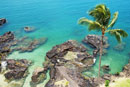
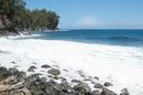
| Hilo, Hawaii |
|
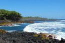
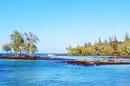
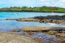
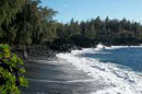
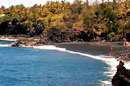
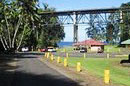
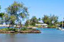
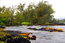
Hilo Bay Beachfront Park |
| |
|
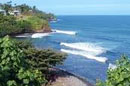
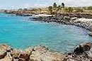
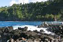
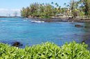
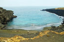
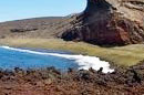
Location at Kamehameha Avenue, Hilo.
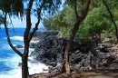
Black sand beach, water is murky and swimming conditions are poor. Hammerhead sharks are common in the bay. A nice place for a picnic and a popular surfing, fishing, kayaking, sailing and canoeing beach. Nice place for watch sunset. Parking, picnic tables, showers, restrooms on the shore. No lifeguard. |
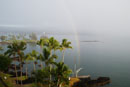
| Hilo, Hawaii |
|
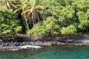
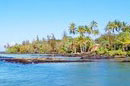
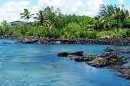
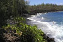
Honoli'i Beach Park |
| |
|
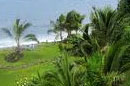
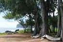
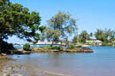
From Hilo, take Hwy 19 north; after the 4-mile marker, turn right onto Nahala St, then left onto Kahoa St. People park on the roadside and walk down to the park.
North of downtown Hilo, the protected cove at Honoli'i Beach Park has Hilo's best bodyboarding and surfing, particularly for beginners. It isn't the best for swimming, as the adjacent river often muddies the waters. Fantastic views of Hilo, lovely grassy picnic area, rest rooms, outdoor showers and a lifeguard. |
 |
| Hilo, Hawaii |
|
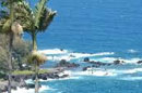
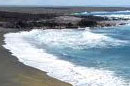
Isaac Hale Beach Park |
| |
|
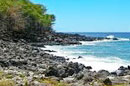
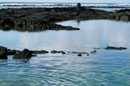
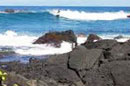
Take Highway 130 south from Pahoa. When it dead ends at Highway 137, turn right. This Park is on the left, near Mile Marker #11.
Isaac Hale Beach Park, also known as Pohoiki is an oceanfront park, boat launch and surf location along Pohoiki Bay in the Puna district of the Big Island of Hawaii.Pohoiki Bay is known for its strong currents and although the park is known for good snorkeling, conditions are usually not ideal. Grass and shadey areas, picnic tables, picnic pavillion, restrooms. |
| Hilo, Hawaii |
|
James Kealoha Beach Park |
| |
|
From downtown Hilo, drive south on Kalanianaole Ave. After four miles, the beach park will be on your left.
James Kealoha Beach Park offers the whole package: nice views, watersports, sunbathing and even a few good fishing spots. Popular water activities include swimming, snorkeling, surfing, pole fishing and spearfishing. Good spot for picnicking with plenty of shade. |
| Hilo, Hawaii |
|
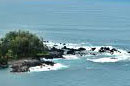
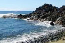
Kapa'a Beach Park |
| |
|
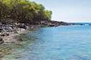
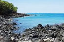
Take Highway 270 north from Kawaihae. Turn left at the road just past Mile Marker #16 to the beach parking area.
Kapa'a Beach Park is a rocky beach is good for snorkeling and scuba diving. The water is clear and usually calm. Offshore there are good views of the neighboring island of Maui. Sunsets are great. Facilities: Picnic tables. BBQ grills. Restrooms. No lifeguards. |
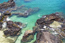
| Hilo, Hawaii |
|
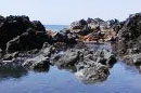
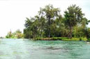
Kapoho Tide Pools |
|
|
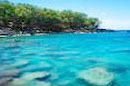
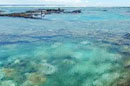
Take Highway 130 south from Pahoa. When it dead ends at Highway 137, turn right. Just before Mile Marker #9, turn left on Kapoho Kai Road. Take the next left on Kaheka and then right on Waiopae. The pools stretch for 1 mile along the coast.
This large collection of tidepools and spring fed pools with volcanically heated. It stretches almost a mile down the coast and extend up to 200 yards out into the ocean. A wide variety of fish, good snorkeling, swimming, and sunbathing. No Facilities. Keep off of private property.
|
| Hilo, Hawaii |
|
Keaukaha Beach Park |
|
|
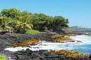
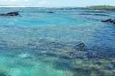
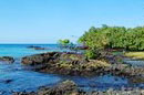
Keaukaha Beach Park is located on the east shore of Hawaii (The Big Island) about 3 miles east of Hilo, HI.
Keaukaha Beach is one of many beaches along this stretch that offers swimming and snorkeling. In addition there are fresh water spring fed ponds scattered throughout.Facilities: parking, restrooms, picnic tables and shower.
|
| Hilo, Hawaii |
|
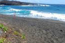
Kehena Beach |
|
|
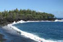
The beach is located in the Puna district (Hilo side) off of Highway 137 near Mile Marker #19. There is a small parking lot on the side of the road. From here, walk towards the left (when facing the ocean). A narrow, steep and rocky trail leads down to the beach.
Kehena Beach is one of the few unofficial "clothing optional" beaches in Hawaii. It is a long, but narrow black-sand beach, also call Dolphin Beach because lot of spinner dolphins in this area. Swimming possible when the ocean is calm, Bodyboarding and fishing both good. No facilities, No lifeguards.
|
| Hilo, Hawaii |
|
Kolekole Beach |
|
|
From Hilo, drive north on Hawaii Belt Road for about 10.5 miles (16.9 km). A sign marks the turnoff to the park on the right.
Kolekole Beach Park is a popular beach park with beautiful scenery, spacious grassy areas and facilities. Great place for picnic and fishing. Swimming in ocean not recommended due to rough conditions. No lifeguards.
|
| Hilo, Hawaii |
|
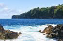
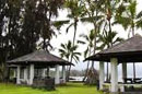
Laupahoehoe Point Beach Park |
|
|
From Hawaii Belt Road (Hwy 19), turn onto Laupahoehoe Point Road (near mile marker 27). Follow the road for about one mile (1.6 km) to the ocean.
Laupahoehoe Point Beach Park is scenic peninsula on the Hamakua Coast. It is a nice spot for a picnic and picture taking, fishing. But when it comes to water activities, the options are limited. Facilites: showers, restrooms, picnic tables, pavilion with electricity, county-maintained boat ramp, parking. No lifeguards.
|
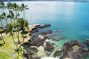
| Hilo, Hawaii |
|
Leleiwi Beach Park |
|
|
Located on Kalanianaole Avenue, east of Hilo.
Leleiwi Beach Park is a small black-sand beach and the rocky shoreline is made up of a few natural ponds, inlets and small rock islets. It is a good beach for swimming, snorkeling, fishing and picnicking. Facilities: showers, restrooms, picnic tables, pavilions, phones, parking, lifeguard.
|
| Hilo, Hawaii |
|
MacKenzie State Park |
|
|
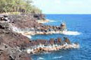
From Pahoa, take Highway 130 south. At the dead end at Highway 137, make a right turn. Highway 137 turns into Pahoiki Road for 2 miles and then Highway 137 turns left. Follow the highway until you see the park on the left after Mile Marker #137.
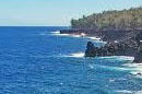
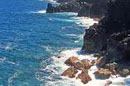
MacKenzie State Park is part of King's Highway, an ancient Hawaiian trail, is located here. Beautiful landscape and ocean views. Swimming is not safe in this area due to very strong currents. Good shoreline fishing but don't too close to the edge of the cliffs. Facilities: restrooms, pavilion, picnic tables, camping area, parking. No lifeguards.
|
|
| Hilo, Hawaii |
|
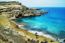
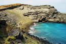
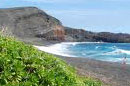
Papakolea Green Sand Beach |
|
|
Papakolea is located at Mahana Bay, three miles northeast of South Point, the southernmost point in the United States. At the end of the paved South Point Raod to Ka Lae (South Point), take the road to the left. Park at the end of the road. This is the first parking lot, which is about 3 miles (4.8 km) away from Papakolea Beach (you'll see a portable bathroom here). From here, it takes about 90 minutes to hike down to the beach. About one mile into the hike, there is a second parking lot. To get to it, you have to make a left turn from the main road about ¼ mile (400 m) before the first parking lot.
Papakolea Beach, located near the Big Island's southern tip, is known for its unique olive green sand. Limited swimming (only when ocean is calm and only close to shore), good fishing. No facilities. No lifeguards.
|
|
| Hilo, Hawaii |
|
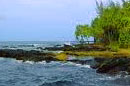
Reeds Bay Beach Park |
|
|
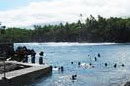
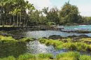
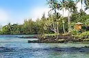
Reeds Bay Beach Park is located at the eastern end of the Waiakea Peninsula, at the end of Banyan Drive.
The bay consists of white sand and coral rubble, most popular area for swimming is the area known as Ice Pond. Fishing and boating both good also.
|
| Hilo, Hawaii |
|
Road to the Sea Black Sand Beach |
|
|
From the Hawaii Belt Road (Highway 11), follow the secondary cinder road called Road to the Sea, which begins 1/3 mile north of mile marker 79. From here it's about 6 miles (9.7 km) to the ocean. This road is suitable for four-wheel drive vehicles only.
Road to the Sea Black Sand Beach are two remote beaches, have black and green sand and are surrounded by lava rocks. Good for fishing and Limited swimming. No facilities. No lifeguards.
|
| Hilo, Hawaii |
|
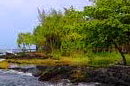
Wai'olena Beach Park |
|
|
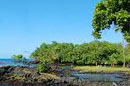
From downtown Hilo, drive east on Kalanianaole Avenue. There is a parking lot on your left at Waiolena Beach Park.
Wai'olena Beach is a lava rock shoreline, good place for picnic, tidepooling and fishing. Facilties: picnic tables, parking.
|
| Copyright 2012 Hilo Magazine |
|
|